


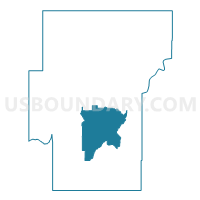
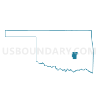
Voting District 31, Hughes County, Oklahoma
About
Outline

Summary
| Unique Area Identifier | 654130 |
| Name | Voting District 31 |
| County | Hughes County |
| State | Oklahoma |
| Area (square miles) | 62.72 |
| Land Area (square miles) | 61.54 |
| Water Area (square miles) | 1.18 |
| % of Land Area | 98.12 |
| % of Water Area | 1.88 |
| Latitude of the Internal Point | 34.95508340 |
| Longtitude of the Internal Point | -96.23533890 |
Maps

Graphs
Select a template below for downloading or customizing gragh for Voting District 31, Hughes County, Oklahoma


Neighbors
Neighoring Voting District (by Name) Neighboring Voting District on the Map
- Voting District 11, Hughes County, OK
- Voting District 18, Hughes County, OK
- Voting District 30, Hughes County, OK
- Voting District 32, Hughes County, OK
- Voting District 33, Hughes County, OK
Top 10 Neighboring County Subdivision (by Population) Neighboring County Subdivision on the Map
Top 10 Neighboring Place (by Population) Neighboring Place on the Map
Top 10 Neighboring Unified School District (by Population) Neighboring Unified School District on the Map
- Holdenville Public Schools, OK (7,437)
- Allen Public Schools, OK (2,319)
- Calvin Public Schools, OK (1,280)
- Moss Public Schools, OK (1,032)
- Stuart Public Schools, OK (998)